After studying fire ecology, I decided to abandon pre-med to pursue a career in Ecology. I never knew there were species of plants that needed forest fires for their seeds to germinate. I learned that a truly healthy forest is often only possible after the clearing of undergrowth from fire. Fascinating facts of fire ecology drive home the importance of fire. But the drying out of once-wet places (i.e the Pacific Northwest) combined with human encroachment have resulted in devastation. In many paces this is becoming the norm. Fires are more intense and spread larger than ever due in part to years of fire suppression. In Colorado we’ve had a wetter than usual start to 2021. I was curious about the forecast for our regional fire season.
Before I dive into the data, I want to say that this was a “quick and dirty” search. I make a lot of generalizations and recognize that there isn’t always a perfect comparison between location and precipitation/fires. To keep it broad, I started by googling current fires in Colorado and found a map showing all 2021 fires. I overlaid it with a precipitation map showing 2021 rainfall (Figure 1). I was curious whether areas where fires occurred were drier than the rest of the state.
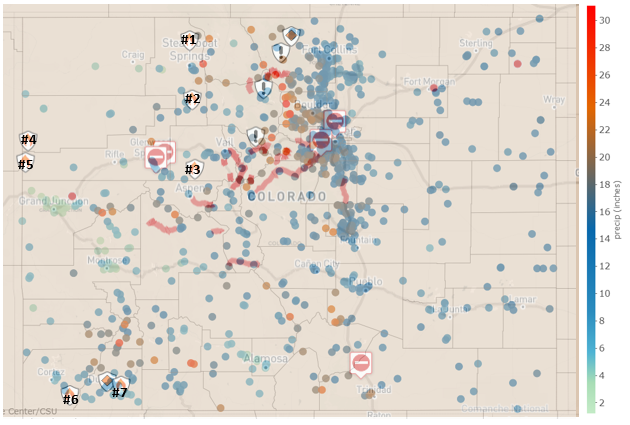
Figure 1: Map of Colorado precipitation from January 1, 2021 through August 13, 2021 overlaid with Colorado’s 2021 fires from Coloradoan.com. The numbers correspond with the numbers in Table 1.
The largest of the fires in Colorado this year was the June Oil Springs Fire which burned near the Utah border (Figure 1, #4). Based on the precipitation map, there were numerous green dots indicating less rainfall relatively close to the fire. The Western Slope clearly did not get as much rainfall as the mountains and Front Range early in 2021.
The second largest fire in Colorado this year was the Morgan Creek Fire outside of Steamboat Springs in the Northeast-Central part of the state. Nearby precipitation totals were a lot higher than the Grand Junction area with some red dots indicating high rainfall relatively close the location of the fire. I had a hard time finding an update on the Morgan Creek fire. As of a few weeks ago, it was only 24% contained. Hopefully the higher precipitation is helping control that fire. Two very small fires also occurred in the southwest portion of the state where rainfall was moderate (Figure 1, #’s 6 and 7).
2020 was one of the most devastating wildfire years in Colorado history. I wanted to compare the 2020 fire season to 2021’s fire season. I tracked down monthly precipitation data for August 2019 through July 2020 and August 2020 through July 2021 for four different locations, 1) the Denver area, where tons of spring rain forced the cancellation of many of my kid’s soccer practices, 2) the Yampa weather station which is relatively close to the 2021 Morgan Creek Fire, 3) the Grand Lake Station which was relatively close to the extremely destructive 2020 Cameron Peak Fire (Colorado’s Largest in history) and East Troublesome Fire which burned a combined 402,725 acres or 520 square miles (9News 2021), and finally, 4) a weather station in Grand Junction which is close to 2020’s third largest fire, Pine Gulch which burned 139,007 acres and is also relatively close to the 2021 Oil Springs Fire.
There are a few things that are apparent from these figures (Figures 2-5), 1) Denver received much more rain in early 2021 than any of the other three sites graphed. 2) Grand Junction was particularly dry in the graphed timeframe which explains the fires in both years. 3) The Grand Lake dataset is fairly interesting. February 2020 saw a relatively high amount of precipitation. While months leading up to the Cameron Peak and East Troublesome Fires were by no means wet, there was still some decent rainfall which would make you think that the extreme fires that occurred should not have been as bad as they were. However, none of the data tell the full picture on the rainfall patterns (all at once vs spread over time), which might help explain the extreme fire situation. The beetle kill was also a particularly destructive component of the 2020 fires.

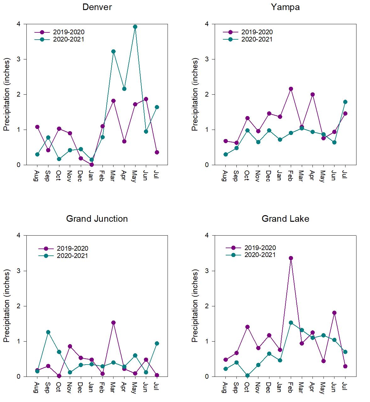
Figures 2-5: Monthly precipitation for four sites from August 2019 through July 2021. Data from Colorado State University's Colorado Climate Center.
What does all this mean for the rest of the 2021 fire season? Well, based on the data I looked at, I have no idea. Clearly the Western Slope needs more rain. I turned to the experts for predictions for the rest of the fire season. According to the Predictive Services National Interagency Fire Center (who knew there was such a thing!):
“Above normal significant fire potential is predicted in August and September across the northwest corner of Colorado through much of Wyoming, South Dakota, and northwest Nebraska.”
“Late June and July precipitation and moderating fire weather conditions resulted in a decrease in new significant fire activity as well as reduced growth on existing large fires.”
“The Climate Prediction Center (CPC) outlook for August indicates drier and warmer than normal conditions over northern portions of the Rocky Mountain Area. More extensive warming and drying is projected for the autumn period, especially west of the Continental Divide.”
Check out the link in the references to read the full story, but it appears the wetter weather is helping reduce fire risk for parts of the state, but unfortunately the rain has not been reaching the entire state leaving many areas at risk for more fires.
When compiling the data on the fires that have occurred in 2021 in Colorado (Table 1), I was surprised to find that all were either confirmed to have been started by lighting or are being investigated but likely started by lighting. After briefly discussing wildfires in California with a colleague, I learned that more than one of those extremely destructive fires was started by transmission lines rather than natural factors. While wildfires these days are becoming more and more destructive, it is frustrating to learn that some of California’s wildfires were preventable. Despite the benefits fire brings to forests, with the spread of people deeper into the forest, fires must be minimized and controlled.
Table 1: Colorado’s 2021 wildfires as of August 23, 2021 from Coloradoan.com.
|
Name of Fire
|
Location on Map
|
% Contained
|
Date Started
|
Cause
|
# Acres Burned
|
|
Morgan Creek Fire
|
1
|
24 as of 8/12/21
|
7/9/21
|
Lightning
|
7,505
|
|
Muddy Slide Fire
|
2
|
70 as of 8/6/21
|
6/20/21
|
Lightning
|
4,093
|
|
Sylvan Fire
|
3
|
90 as of 8/20/21
|
6/20/21
|
Lightning
|
3,792
|
|
Oil Springs Fire
|
4
|
99 as of 7/6/21
|
6/18/21
|
Lightning
|
12,613
|
|
Wild Cow Fire
|
5
|
100 as of 6/28/21
|
6/21/21
|
Lightning Suspected
|
560
|
|
Trail Canyon
|
6
|
90 as of 6/22/21
|
6/18/21
|
Lightning
|
881
|
|
Vosburg Pike
|
7
|
100 as of 7/17/21
|
6/16/21
|
Under Investigation
|
67
|
References
9News. https://www.9news.com/article/news/local/wildfire/colorado-2020-historic-wildfire-season/73-c9458147-c945-45e6-bea9-a1d426cca102 Accessed August 23, 2021.
Colorado State University; Colorado Climate Center. Precipitation map and precipitation data. https://climate.colostate.edu/ Accessed August 13, 2021.
Coloradoan.com. Hazard Mapping System: Fire and Smoke. https://data.coloradoan.com/fires/ Accessed August 13, 2021.
Predictive Services National Interagency Fire Center. 2021. National Significant Wildland Fire Potential Outlook. Issued: August 1, 2021.
Natalie Love is the Laboratory Director at GEI Consultants, Inc. GEI conducts Whole Effluent Toxicity (WET) Testing, low-level nutrient analysis, and benthic macroinvertebrate identifications. She lives in Denver with her husband, 2 daughters, and Belgian Malinois, Nacho.